


Two Rovers, Two Panoramas: NASA Reveals Two Eras of Mars
Apr 28, 2026
Soumyadeep Mukherjee
Soumyadeep Mukherjee is an award-winning astrophotographer from India. He has a doctorate degree in Linguistics. His work extends to the sub-genres of nightscape, deep sky, solar, lunar and optical phenomenon photography. He is also a photography educator and has conducted numerous workshops. His works have appeared in over 40 books & magazines including Astronomy, BBC Sky at Night, Sky & Telescope among others, and in various websites including National Geographic, NASA, Forbes. He was the first Indian to win “Astronomy Photographer of the Year” award in a major category.
Share:
Planetary geology relies on context. A single rock sample can reveal chemistry, but a landscape reveals history. In recent work, NASA has combined high-resolution panoramas from two active rovers to examine Mars at very different stages of its evolution. These panoramas, captured by the Curiosity rover and Perseverance rover, provide spatial continuity, stratigraphic context, and environmental clues that extend across billions of years. The two datasets come from separate regions of Mars. One represents a later phase of environmental change. The other preserves conditions from the planet’s earliest stable surface.
Two rovers, two geological contexts
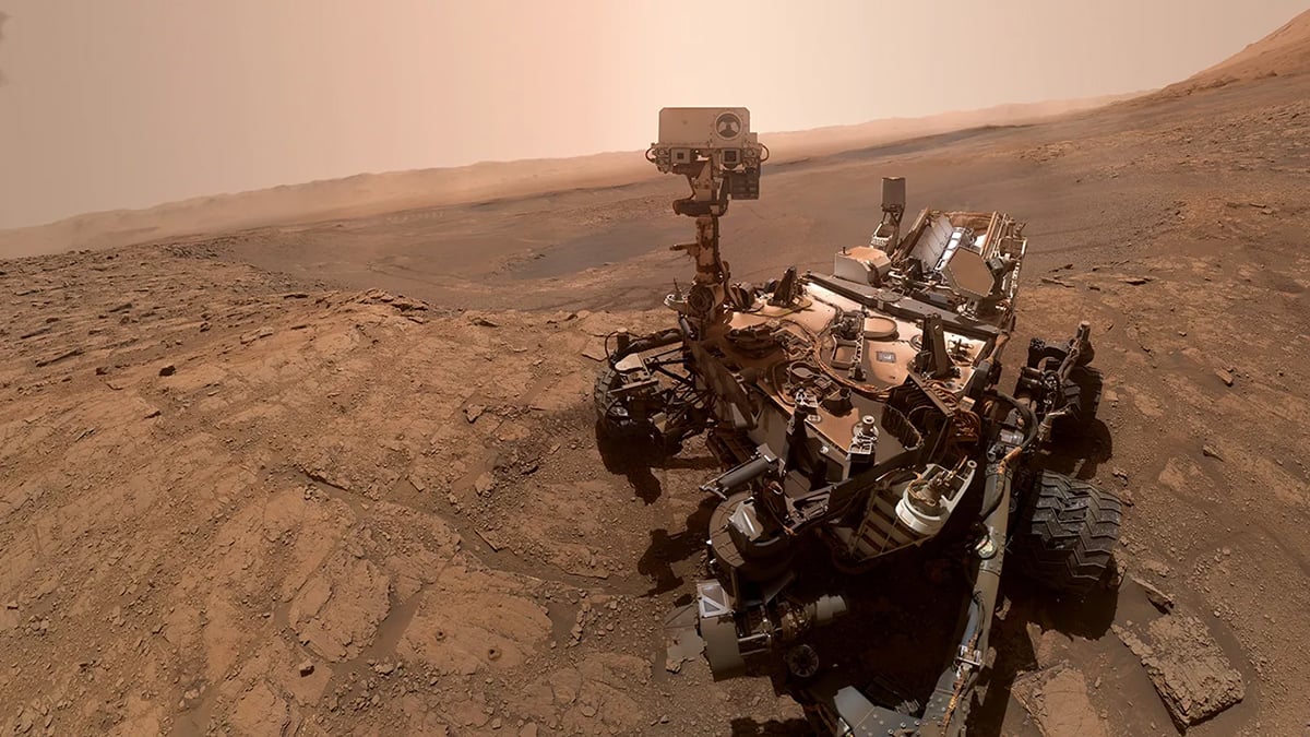
The two rovers operate in fundamentally different geological settings. Curiosity continues its work inside Gale Crater, a large basin that hosts a central sedimentary mound known as Mount Sharp. This mound formed through long-term deposition of sediments. Over time, wind erosion exposed these layers, making them accessible for study. Each layer reflects a specific environmental phase, often linked to water activity, sediment transport, or atmospheric change.
As Curiosity ascends Mount Sharp, it effectively moves upward through younger geological units. This vertical progression enables scientists to track the evolution of conditions from wetter to drier environments. The rover’s route is not random. Orbital data, mineral signatures, and terrain accessibility guide it.
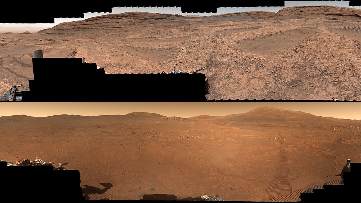
In contrast, Perseverance explores Jezero Crater, a site selected for its ancient origin. Jezero formed billions of years ago, during a period when Mars supported stable liquid water on its surface. The crater once hosted a lake, fed by inflowing channels that carried sediments from surrounding highlands.
Unlike Gale, which emphasizes environmental transitions, Jezero preserves an early snapshot of Mars. The rocks here have experienced less overprinting by later processes. As a result, they retain information about the planet’s initial conditions, including its hydrology and geochemistry.
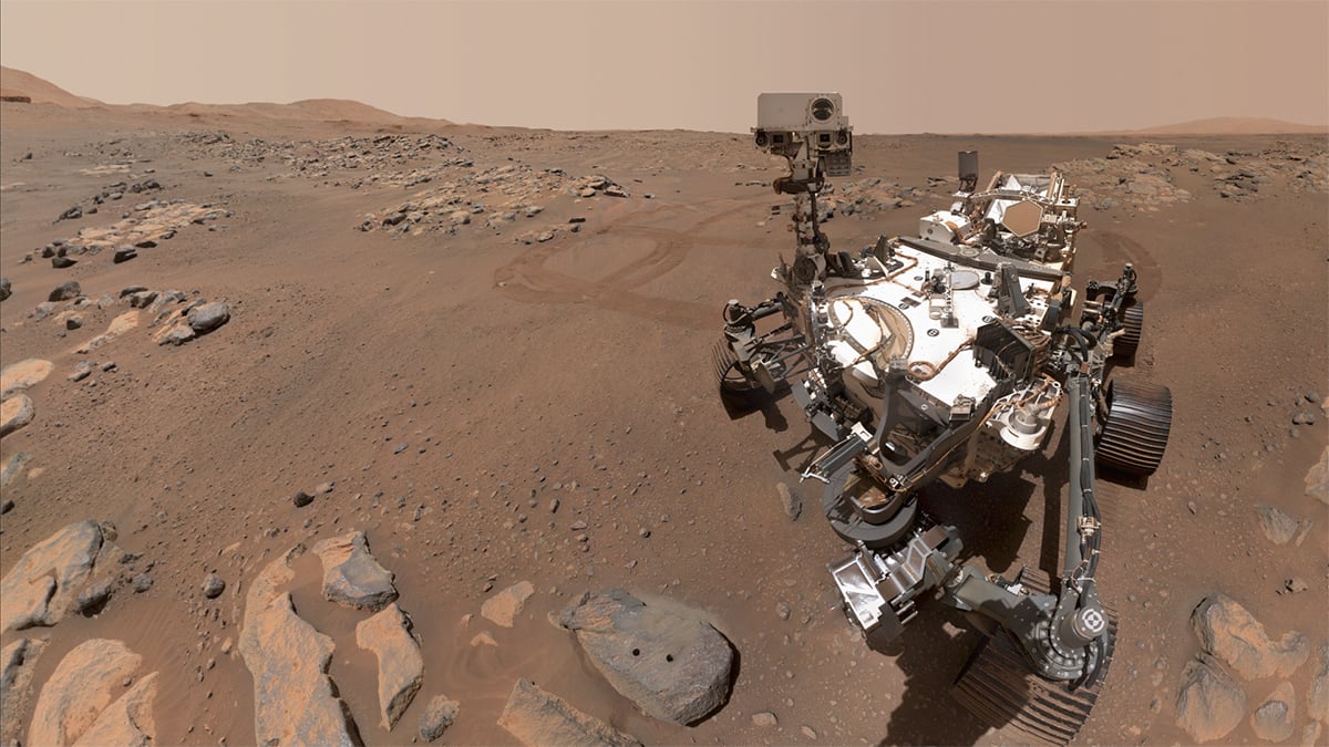
Curiosity’s panorama and subsurface water systems
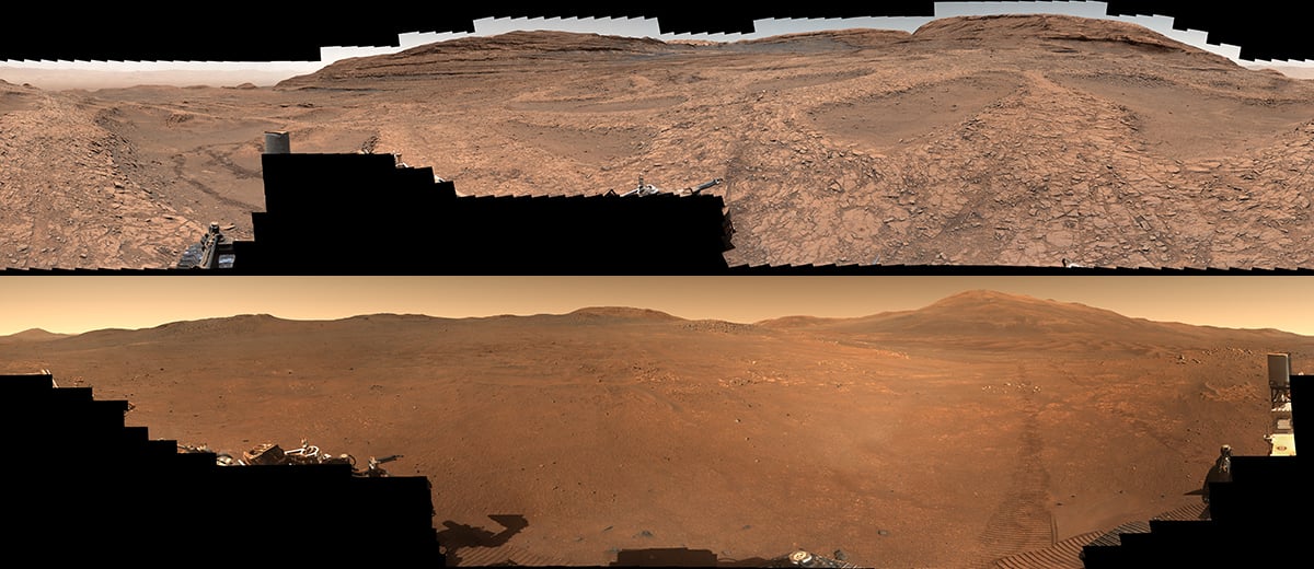
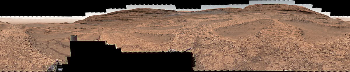
The panorama captured by Curiosity represents one of its most detailed mosaics. It combines more than a thousand individual frames into a continuous, high-resolution view. The scene reveals a terrain dominated by intersecting ridges, forming a pattern that appears almost geometric.
These features, known as boxwork structures, have drawn significant attention. Their formation requires a sequence of processes that involve water, mineral transport, and erosion. Initially, fractures develop in the rock due to stress. Groundwater then flows through these fractures, carrying dissolved minerals. Over time, these minerals precipitate and fill the cracks, forming hardened veins.
Subsequently, wind erosion removes the surrounding, less resistant material. What remains is a network of mineralized ridges that trace the original fracture system. This process does not occur in dry conditions. It requires sustained interaction between water and rock.
Curiosity has already identified organic molecules within Gale Crater. These compounds are not evidence of life, but they confirm that the chemical ingredients were present. When combined with evidence of groundwater, they point to environments that could have supported microbial ecosystems.
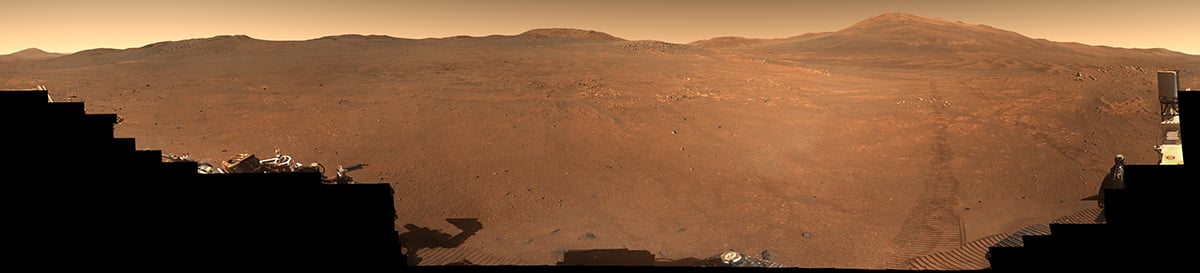
Perseverance’s panorama and ancient lake deposits
The panorama from Perseverance presents a different type of landscape. It focuses on terrain near the rim of Jezero Crater, including a region known as Lac de Charmes. The geological context here is older and more complex.
The rocks in this area formed during the early history of Mars, when volcanic activity, impact processes, and surface water all interacted. Jezero’s lake system developed when water flowed into the crater and accumulated over time. Sediments carried by these flows settled in the basin, forming layered deposits.
These deposits are of particular interest because they can preserve biosignatures. On Earth, similar environments often trap and protect organic material. Fine-grained sediments, such as clays, can encapsulate chemical traces and shield them from degradation.
The panorama allows scientists to understand the spatial relationships between different rock units. It also helps identify depositional features, such as ancient shorelines or delta structures. By studying these features, researchers can reconstruct the hydrological conditions that existed when the lake was active. They can estimate water depth, flow rates, and sediment sources.
Imaging Strategy and Mosaic Construction
The creation of these panoramas involves planning and execution. Both rovers rely on mast-mounted camera systems capable of capturing high-resolution images across wide fields of view.
The imaging process begins with a sequence of overlapping frames. Each frame captures a small portion of the landscape. The rover adjusts its mast position between exposures to cover the full scene. Lighting conditions, camera calibration, and exposure settings must remain consistent to ensure uniformity.
Once transmitted to Earth, the images undergo processing. Engineers align the frames based on common features. They correct for distortions, adjust color balance, and blend the edges to produce a seamless mosaic.
The combined analysis of these panoramas supports a broader effort to reconstruct the environmental history of Mars. Evidence from both sites indicates that the planet once supported stable liquid water.
Clear skies!

Soumyadeep Mukherjee
Soumyadeep Mukherjee is an award-winning astrophotographer from India. He has a doctorate degree in Linguistics. His work extends to the sub-genres of nightscape, deep sky, solar, lunar and optical phenomenon photography. He is also a photography educator and has conducted numerous workshops. His works have appeared in over 40 books & magazines including Astronomy, BBC Sky at Night, Sky & Telescope among others, and in various websites including National Geographic, NASA, Forbes. He was the first Indian to win “Astronomy Photographer of the Year” award in a major category.


Join the Discussion
DIYP Comment Policy
Be nice, be on-topic, no personal information or flames.