


“Love from Above”: ESA’s Sentinel-2 Reveals Egypt’s Heart from Space
Feb 17, 2026
Soumyadeep Mukherjee
Soumyadeep Mukherjee is an award-winning astrophotographer from India. He has a doctorate degree in Linguistics. His work extends to the sub-genres of nightscape, deep sky, solar, lunar and optical phenomenon photography. He is also a photography educator and has conducted numerous workshops. His works have appeared in over 40 books & magazines including Astronomy, BBC Sky at Night, Sky & Telescope among others, and in various websites including National Geographic, NASA, Forbes. He was the first Indian to win “Astronomy Photographer of the Year” award in a major category.
Share:

Multispectral Earth observation has transformed how scientists monitor vegetation, water distribution, and land use across arid regions. Among the most capable systems in this domain is the Copernicus Sentinel-2 mission. The satellite pair delivers high-resolution optical data with frequent revisit times and strong radiometric stability. These characteristics make Sentinel-2 particularly effective for agricultural and environmental monitoring.
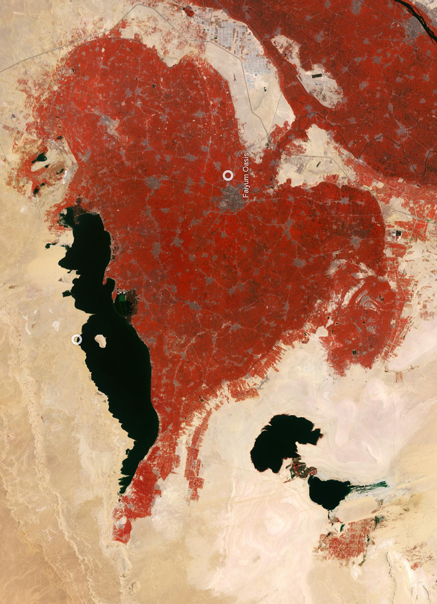
On 13 February 2026, the European Space Agency released a new mosaic from this mission as part of its Earth from Space series. The image covers northern Egypt in a near-infrared false-colour composite. At the centre of the frame lies the Fayum Oasis, whose outline closely resembles a heart. While the Valentine theme attracted public attention, the dataset itself demonstrates the analytical strength of modern multispectral imaging. ESA generated the mosaic using cloud-free observations collected between July and December 2025. Engineers combined multiple Sentinel-2 passes to produce a clean regional view.
The Fayum Oasis: A distinct geomorphological basin
The focal point of the image is the Fayum Oasis, located roughly 100 kilometres southwest of Cairo. Geologically, Fayum forms a natural depression connected to the Nile through the Bahr Yussef canal. This hydraulic link distinguishes it from many other Saharan oases that depend primarily on groundwater.
The basin has supported continuous human occupation for thousands of years. Archaeological evidence indicates agricultural activity in the region for more than eight millennia. Today, intensive farming covers most of the depression. In the Sentinel-2 composite, these cultivated zones appear as dense red textures because of the false-colour processing.
The heart-like outline of Fayum is not artificial. It results from the natural shape of the depression combined with the distribution of irrigated land. ESA highlighted this coincidence in its Valentine release, but the feature has long been visible in satellite imagery.
Immediately north of the oasis sits Lake Qaroun. The lake appears dark in the composite due to its water signature. Historically, it represents the shrinking remnant of the much larger Lake Moeris. Its presence helps define the northern boundary of the Fayum basin and strengthens the overall heart-shaped appearance.
Interpreting the false-colour composite
The ESA image’s colour palette may appear unusual. Vegetation appears in bright red rather than green. This effect results from the near-infrared mapping used in the composite. Sentinel-2 records reflected light across multiple spectral bands, including the near-infrared region. Healthy vegetation reflects strongly at these wavelengths because of leaf cellular structure. ESA mapped this strong near-infrared signal into the red channel of the final image. Consequently, areas with vigorous plant growth appear bright red.
Meanwhile, desert surfaces reflect differently and therefore appear in muted yellow-brown shades. Urban regions, dominated by concrete and asphalt, show up in grey tones. This spectral separation makes land-cover patterns immediately clear.
The technique is widely used in agricultural monitoring. It allows analysts to identify crop health, irrigation extent, and seasonal changes quickly. In the Egyptian scene, the method sharply outlines the fertile Nile corridor against the surrounding desert.
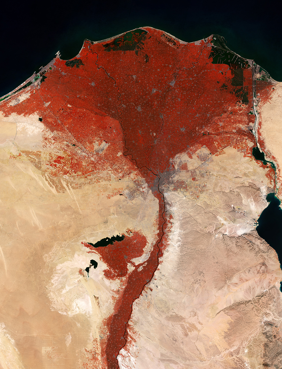
The Nile Delta: A concentrated agricultural zone
The upper portion of the mosaic reveals the Nile Delta spreading toward the Mediterranean coast. In the false-colour rendering, the delta forms a broad triangular region of intense red. This visual density reflects the heavy concentration of agriculture in the area.
According to ESA, less than three percent of Egypt’s total land area is suitable for farming. The country, therefore, depends heavily on the Nile system. The Sentinel-2 view illustrates this dependency with unusual clarity.
Within the delta, individual agricultural parcels create a fine patchwork pattern. Variations in red tone indicate differences in crop type and growth stage. Major crops in the region include rice, cotton, and sugar cane. All rely on controlled irrigation from Nile distributaries.
The image also reveals subtle geographic trends. Irrigated land extends more widely on the western side of the delta, where the terrain is flatter. This topographic advantage allows water to spread more efficiently across the fields.

Urban signatures and human geography
Human settlement patterns appear clearly in the Sentinel-2 mosaic. Built-up areas reflect light differently from vegetation and therefore appear in shades of grey. The most prominent urban cluster is Cairo, located at the apex of the Nile Delta.
Cairo’s position is not accidental. The city developed where the Nile begins to branch into multiple distributaries. This location historically offered reliable water access highlights.
With sufficient zoom, the Giza plateau becomes visible southwest of the city. Even the pyramid complex can be identified in high-resolution Sentinel-2 data. This level of detail underscores the mission’s spatial capability.
Perhaps the most instructive observation is the sharp boundary between populated and unpopulated regions. Dense development closely follows the Nile and irrigated farmland. Beyond these zones, the Sahara remains largely empty.

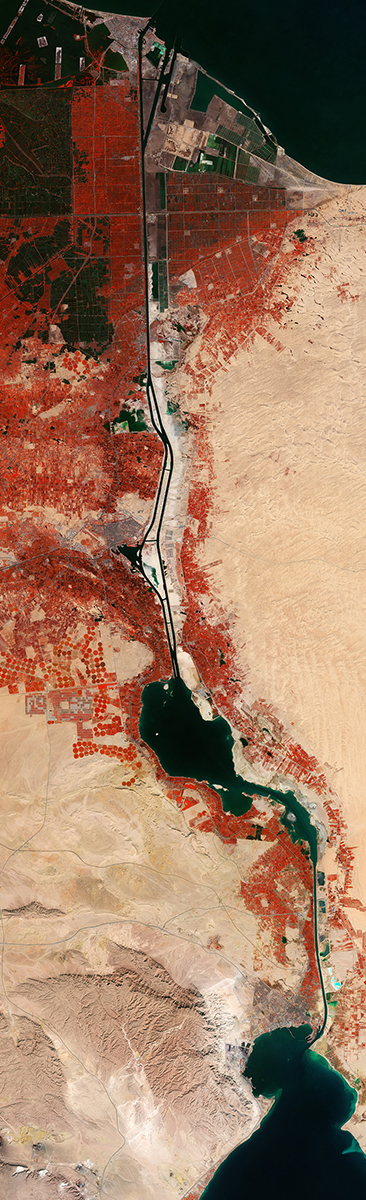
The Suez Canal: Linear infrastructure from orbit
On the eastern side of the scene, the Suez Canal appears as a narrow, straight feature. Its geometry contrasts strongly with the natural curves of the Nile system. This difference makes the canal easy to identify in multispectral imagery.
The canal connects the Mediterranean Sea to the Red Sea and serves as a major global shipping route. Because of its economic importance, Earth-observation satellites frequently monitor the surrounding region.
In the Sentinel-2 composite, the canal demonstrates another advantage of high-resolution optical imaging. Linear infrastructure stands out clearly against the surrounding terrain. Analysts can use such imagery to track coastal change, port development, and land-use activity along the corridor.
Building the cloud-free mosaic
Producing a clean regional image over northern Egypt requires careful data selection. Atmospheric haze and occasional cloud cover can degrade individual satellite passes. ESA addressed this challenge by constructing a multi-temporal mosaic.
The agency combined Sentinel-2 observations acquired between July and December 2025. Engineers screened the dataset and selected only cloud-free pixels. They then merged these pixels into a seamless composite.
This workflow is standard in modern Earth observation but remains technically demanding. It requires precise geometric alignment and radiometric consistency between scenes. Sentinel-2’s stable calibration makes such processing feasible on a routine basis.

Clear skies!

Soumyadeep Mukherjee
Soumyadeep Mukherjee is an award-winning astrophotographer from India. He has a doctorate degree in Linguistics. His work extends to the sub-genres of nightscape, deep sky, solar, lunar and optical phenomenon photography. He is also a photography educator and has conducted numerous workshops. His works have appeared in over 40 books & magazines including Astronomy, BBC Sky at Night, Sky & Telescope among others, and in various websites including National Geographic, NASA, Forbes. He was the first Indian to win “Astronomy Photographer of the Year” award in a major category.


Join the Discussion
DIYP Comment Policy
Be nice, be on-topic, no personal information or flames.