


ESA’s Mars Express Reveals a Water-Carved Landscape on Mars
May 16, 2026
Soumyadeep Mukherjee
Soumyadeep Mukherjee is an award-winning astrophotographer from India. He has a doctorate degree in Linguistics. His work extends to the sub-genres of nightscape, deep sky, solar, lunar and optical phenomenon photography. He is also a photography educator and has conducted numerous workshops. His works have appeared in over 40 books & magazines including Astronomy, BBC Sky at Night, Sky & Telescope among others, and in various websites including National Geographic, NASA, Forbes. He was the first Indian to win “Astronomy Photographer of the Year” award in a major category.
Share:
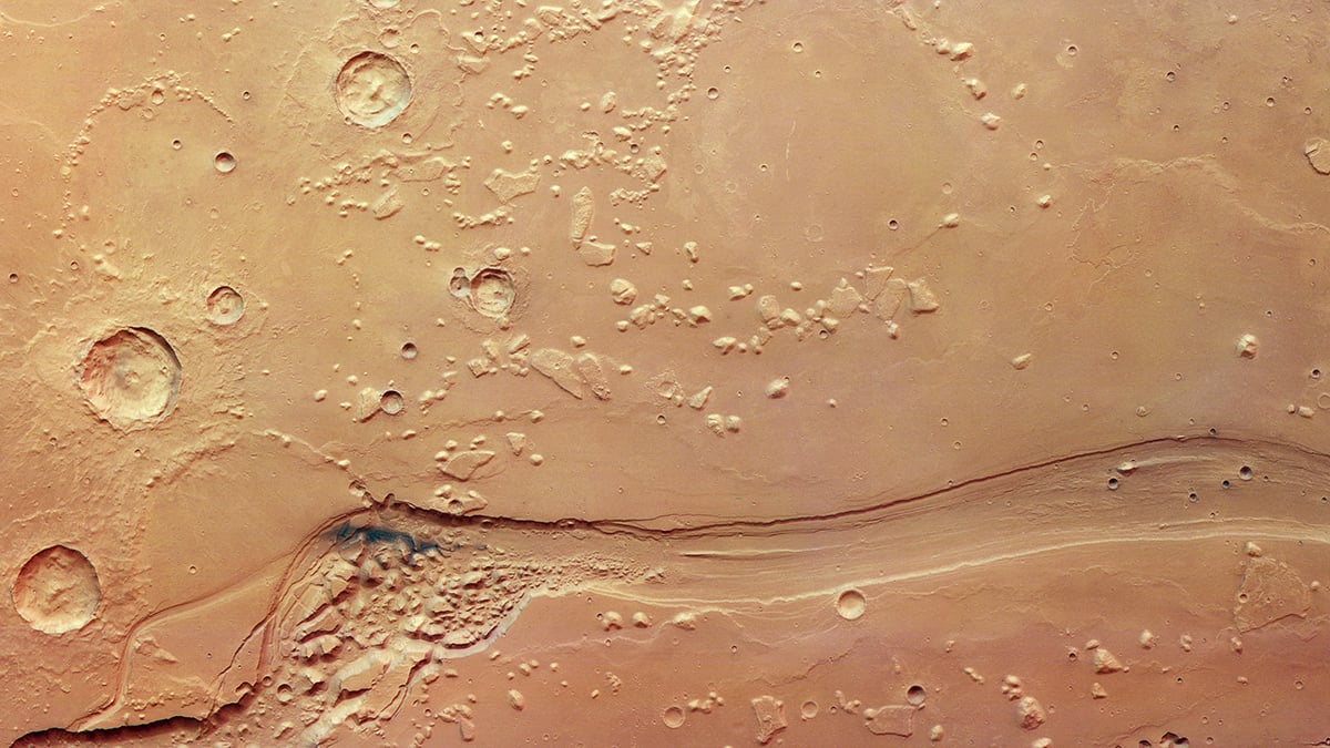
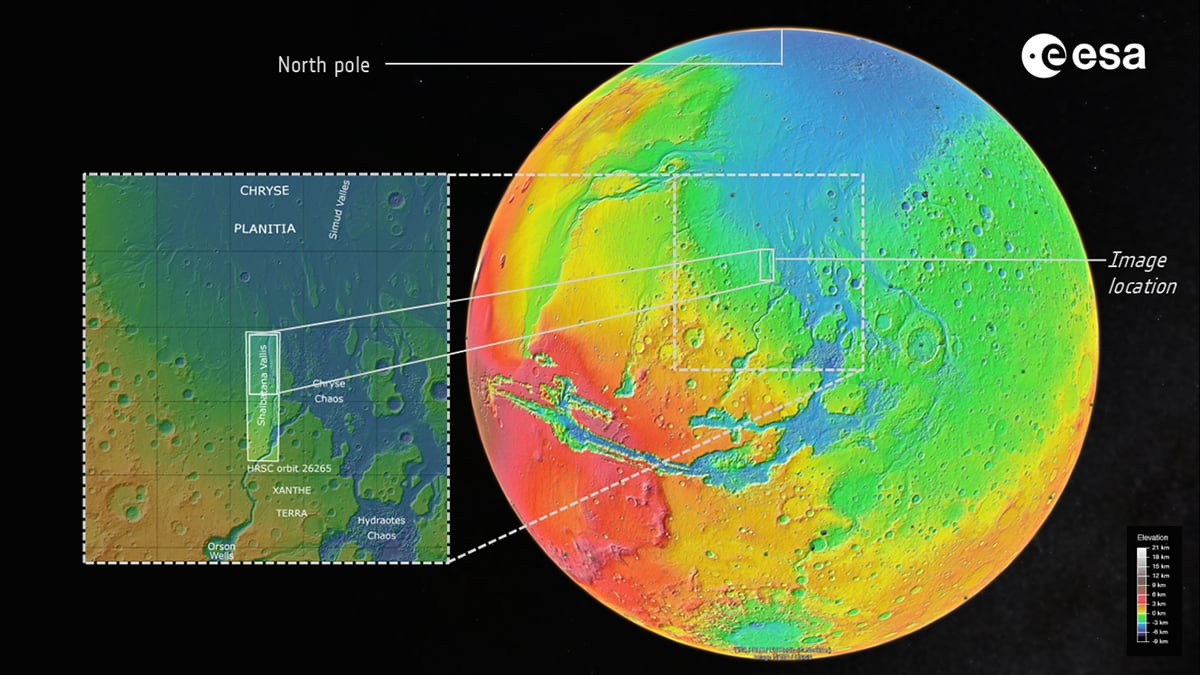
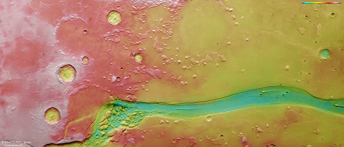
High-resolution orbital imaging has revealed how strongly water shaped the ancient Martian surface. Several valley systems on Mars exhibit geomorphological features indicative of large-scale flooding, surface collapse, and long-term erosion. One of the most significant examples is Shalbatana Vallis, a prominent outflow channel situated near the transition between the southern highlands and the northern plains.
The European Space Agency recently released a new set of images of this region from the Mars Express spacecraft. The observations came from the orbiter’s High Resolution Stereo Camera. The new imagery reveals a landscape that has been shaped by multiple geological processes over billions of years. Giant flood channels cut through fractured terrain, and volcanic deposits cover older surfaces.
Shalbatana Vallis: Evidence of catastrophic flooding
Shalbatana Vallis forms part of a vast network of outflow channels spread across equatorial Mars. The valley extends for nearly 1300 kilometers and reaches widths of around 10 kilometers in some areas. Depth measurements from orbital data show sections approaching 500 meters below the surrounding terrain. These dimensions separate the valley from ordinary erosion features. Scientists classify it as a catastrophic flood channel.
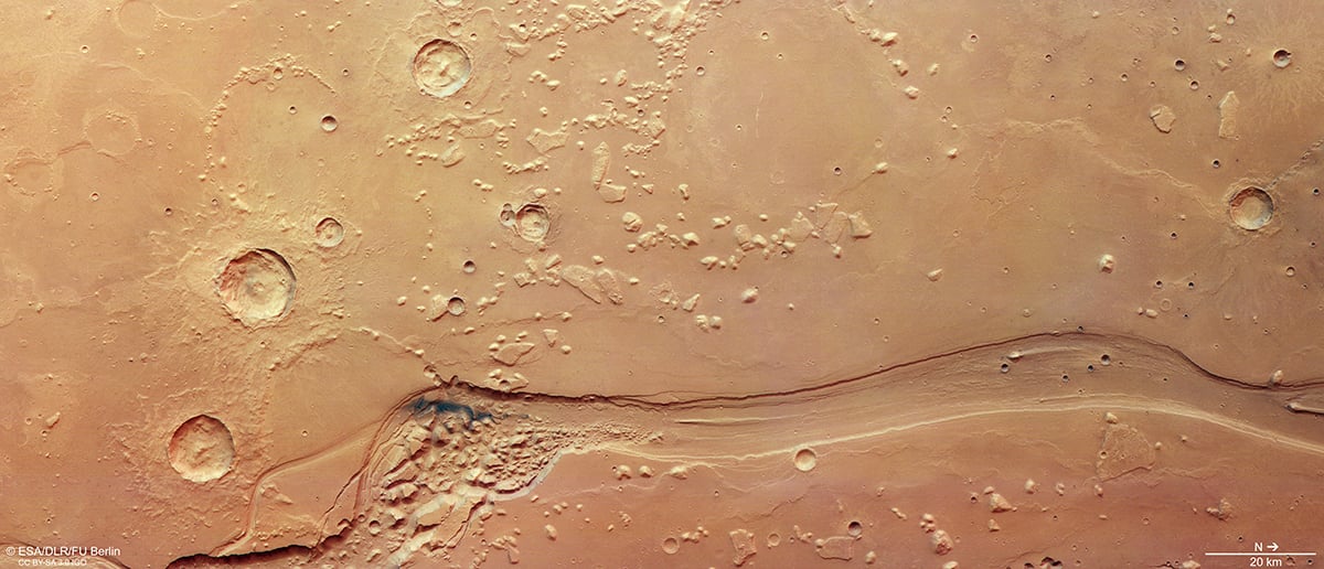
Researchers believe the valley formed around 3.5 billion years ago during a period when Mars remained geologically active. At that time, the planet likely possessed large underground reservoirs of water and ice. Heat from volcanism, crustal movement, or pressure buildup beneath frozen surface layers may have destabilized those reservoirs. Once released, the water moved rapidly across the landscape and excavated massive channels in the crust.
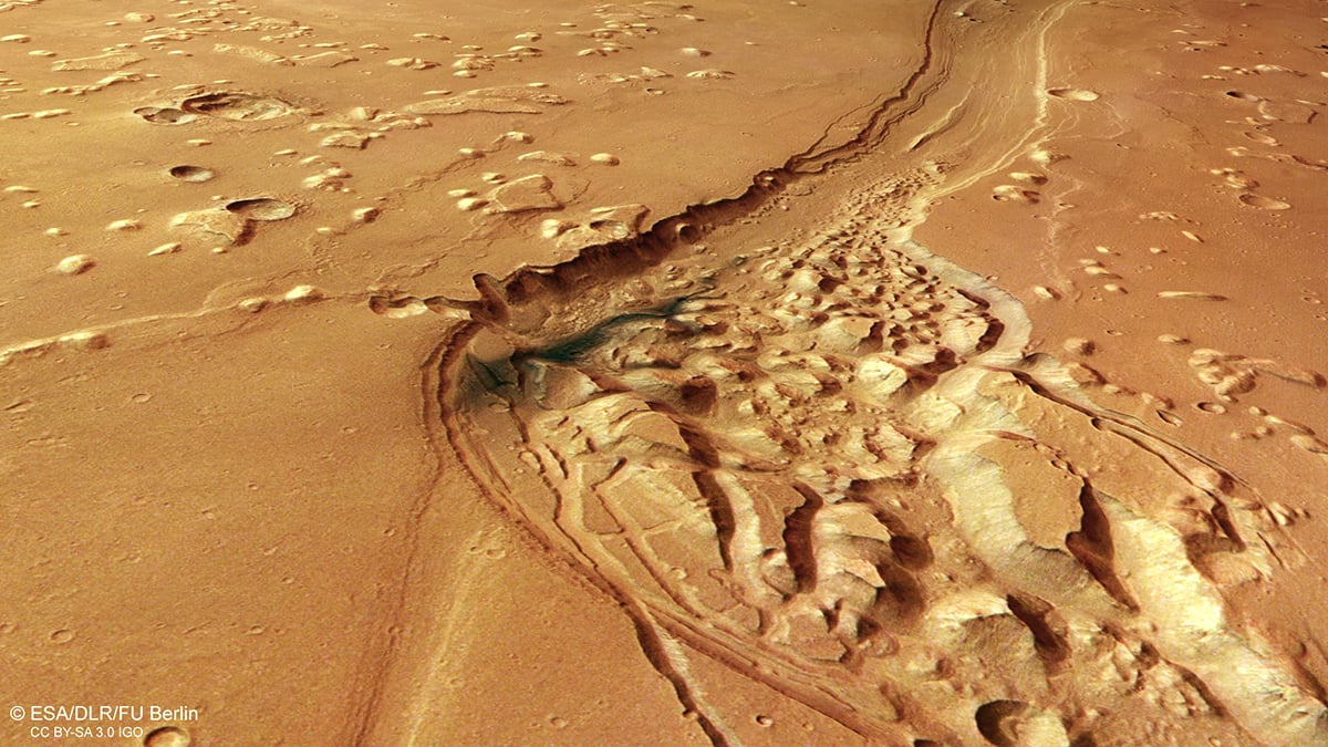
The stereo data reveals subtle elevation changes across the valley floor and surrounding plains. It also shows erosional textures that help scientists reconstruct the direction and force of ancient floodwaters. In several regions, the terrain appears stripped down to older geological layers, suggesting extremely energetic flow conditions.
Chaos Terrain: Collapsing underground reservoirs
One of the most striking elements in the ESA images is the presence of chaos terrain near the outflow channel. These regions appear fragmented and unstable, with irregular blocks separated by depressions, fractures, and collapsed surfaces. Instead of smooth plains, the terrain resembles a broken crust disrupted by internal collapse.
Planetary geologists have linked this type of landscape to subsurface water activity for decades. In many Martian regions, chaos terrain occurs beside major outflow channels. This spatial relationship suggests a direct connection between underground water reservoirs and catastrophic flooding events.
In the case of Shalbatana Vallis, scientists think buried ice or groundwater once occupied large cavities beneath the surface. As subsurface material melted or drained away, the overlying crust lost structural support. The ground then fractured and collapsed into the empty spaces below. Over time, this process produced the chaotic landscape visible today.
Volcanic activity reshaping the region after the floods
Although water dominates the geological story of Shalbatana Vallis, the new images also reveal extensive signs of volcanism across the surrounding terrain. Dark deposits spread across parts of the valley floor and nearby plains. ESA scientists interpret these materials as volcanic ash or fine-grained volcanic sediments later redistributed by wind activity.
The broader region also contains wrinkle ridges that formed after lava flows cooled and contracted. These ridges appear as low, folded structures crossing smoother plains around the valley system. Similar features occur in volcanic provinces elsewhere on Mars and on the Moon. Their presence indicates that volcanic resurfacing modified the region after the major flood events had already occurred.
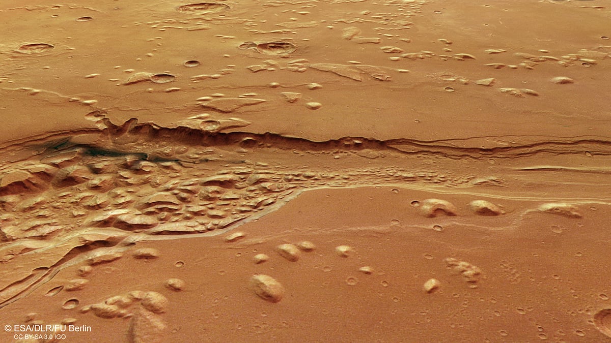
The images also show partially buried impact craters within the smoother plains. Some crater rims remain visible above younger deposits, while others appear heavily eroded or filled with sediments. These relationships help scientists estimate the relative timing of flooding, volcanism, and resurfacing across the region.
In several places, isolated mesas rise above the lower surrounding plains. These remnants likely formed when erosion removed softer material from around more resistant rock layers. Such features preserve fragments of older geological surfaces that once extended across much larger areas.
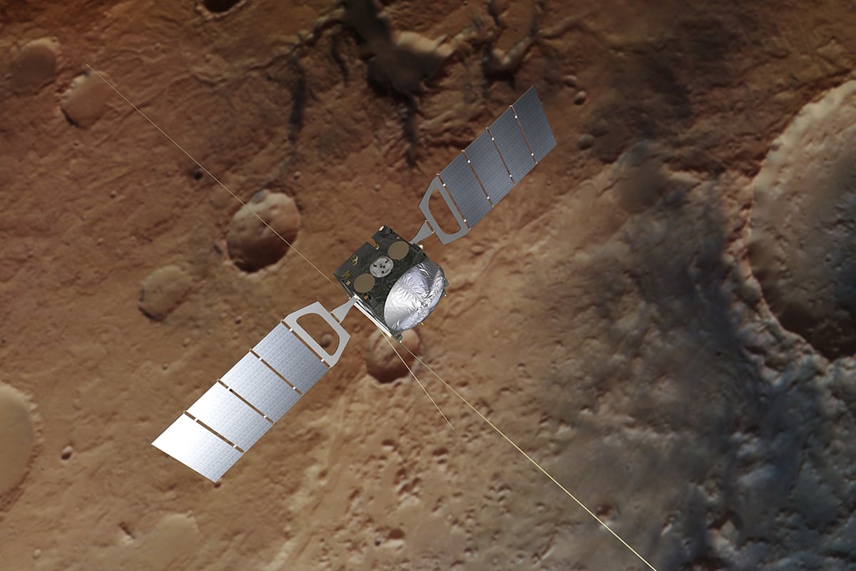
ESA’s Mars Express
ESA launched Mars Express in 2003, making it one of the longest-operating spacecraft currently studying Mars. Despite its age, the mission continues to produce valuable scientific observations. The High Resolution Stereo Camera remains central to that effort because it provides detailed color imaging and topographic mapping of the Martian surface.
Over the past two decades, Mars Express has contributed to the study of water-related minerals, polar ice deposits, atmospheric escape, volcanic provinces, and subsurface structures. The mission has also helped scientists investigate how Mars transitioned from a wetter and warmer world into the cold, dry environment seen today.
Clear skies!

Soumyadeep Mukherjee
Soumyadeep Mukherjee is an award-winning astrophotographer from India. He has a doctorate degree in Linguistics. His work extends to the sub-genres of nightscape, deep sky, solar, lunar and optical phenomenon photography. He is also a photography educator and has conducted numerous workshops. His works have appeared in over 40 books & magazines including Astronomy, BBC Sky at Night, Sky & Telescope among others, and in various websites including National Geographic, NASA, Forbes. He was the first Indian to win “Astronomy Photographer of the Year” award in a major category.


Join the Discussion
DIYP Comment Policy
Be nice, be on-topic, no personal information or flames.