


When Martian Ground Falls Apart: Mars Express Photographs Acheron Fossae
Aug 12, 2025
Soumyadeep Mukherjee
Soumyadeep Mukherjee is an award-winning astrophotographer from India. He has a doctorate degree in Linguistics. His work extends to the sub-genres of nightscape, deep sky, solar, lunar and optical phenomenon photography. He is also a photography educator and has conducted numerous workshops. His works have appeared in over 40 books & magazines including Astronomy, BBC Sky at Night, Sky & Telescope among others, and in various websites including National Geographic, NASA, Forbes. He was the first Indian to win “Astronomy Photographer of the Year” award in a major category.
Share:

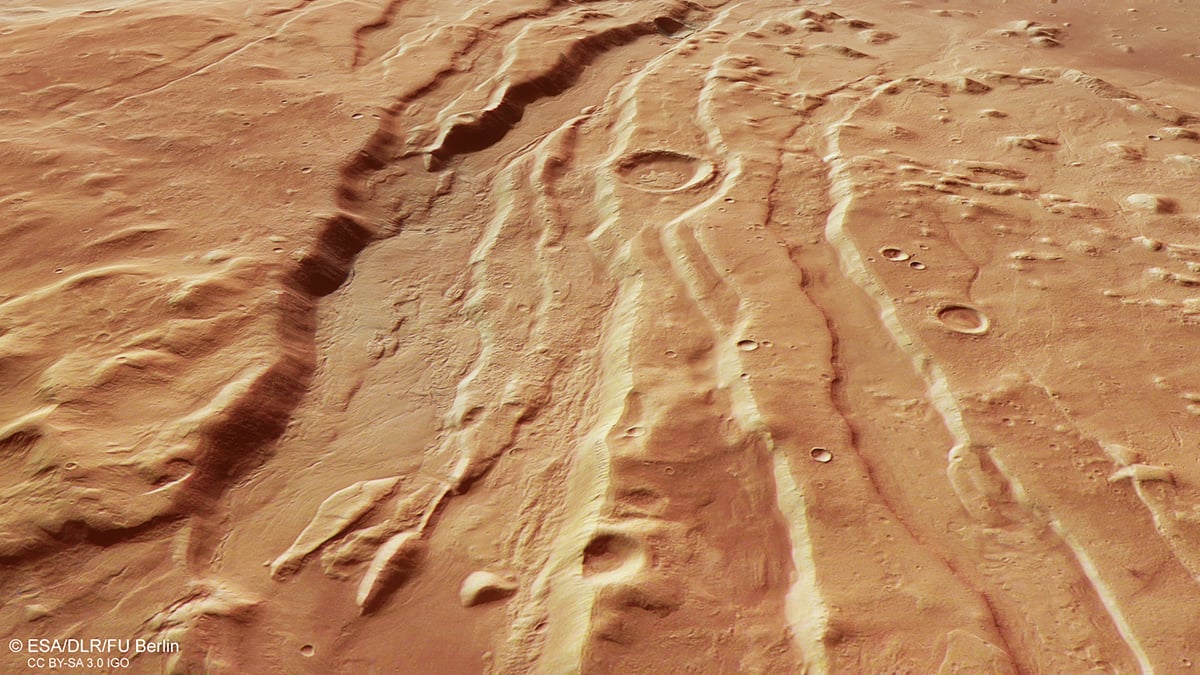
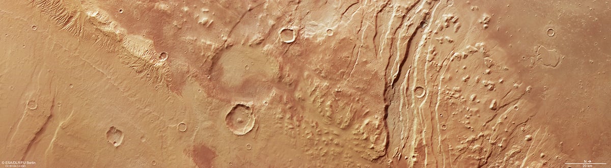
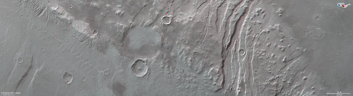
Earlier this month, the European Space Agency released a new, high-resolution view of Acheron Fossae on Mars. The scene focuses on the western edge of a vast graben system. It shows deep fissures, raised blocks, and valley floors smoothed by slow flows. These images combine colour, stereo, and topography in a single dataset. They help scientists read a complex history of tectonics, volcanism, and ice. The release highlights the continuing payoff of long-lived orbiters.
A scar in the crust
Acheron Fossae is a broad network of parallel troughs and faults. Planetary scientists call these landforms “fossae.” The landscape shows alternating horsts and grabens. A horst is a raised block of crust. A graben is a lowered trough between faults. This horst-and-graben architecture forms when the crust stretches and breaks. Rising molten material beneath the crust likely pulled the ground apart. ESA notes the main activity likely dates to more than 3.7 billion years ago. Some troughs extend for many hundreds of kilometres. Those lengths and depths make Acheron a classic example of tectonic stretching.

Scientists estimate relative ages using crater counts and geologic mapping. Crater counting compares the number of impacts across different surfaces. More craters usually indicate an older surface age. Teams calibrate crater rates using lunar sample ages and dynamical models. Automated and manual counting tools produce model ages for surfaces. Groups at Freie Universität Berlin and USGS use these techniques on Mars. Applying crater statistics to Acheron helps bracket the timing of flows. The method constrains timing even when absolute ages remain uncertain.
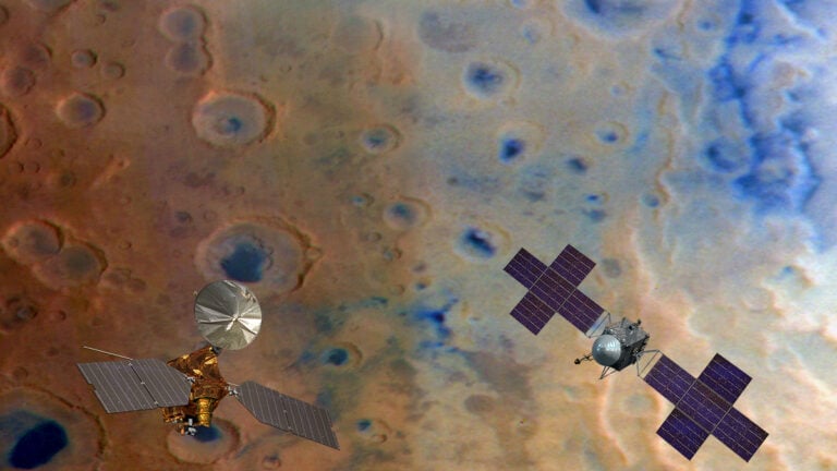
Mars Express and HRSC
Mars Express launched on 2 June 2003 and reached Mars in December 2003. It remains in operation more than two decades later. The orbiter carries eight scientific instruments. Key payloads include HRSC, OMEGA, and MARSIS. HRSC images Mars in colour and stereo at about 10 metres per pixel. Selected areas are imaged at two metres per pixel for finer detail. HRSC also includes a Super Resolution Channel that embeds higher-resolution frames. DLR developed and operates HRSC. The DLR Institute of Planetary Research performed systematic processing. Freie Universität Berlin created the public image products shown by ESA. HRSC is a multi-sensor pushbroom camera using parallel CCD line sensors. The instrument acquires simultaneous stereo and multispectral information across wide swaths. Scientists invert those stereo pairs to build digital terrain models. Those models show slopes, cliff heights, and valley depths in real relief. Colour plus topography makes it easier to separate dust, bedrock, and ice-rich deposits. This combination, colour, stereo, and topography, is what gives the Acheron images their scientific power.

What we see on the valley floors
The valley floors in the new frames show smooth, sinuous textures. Gentle, meandering lines run down the low areas. These lines look river-like at first glance. But morphology reveals a different agent. Researchers interpret these features as slow, viscous flows of ice-rich debris. On Earth, similar landforms are rock glaciers. Rock glaciers contain coarse rock mixed with interstitial ice. They deform and creep under gravity over long timescales. ESA and DLR describe the Martian valley fills as analogous to terrestrial rock glaciers. Those flows act as sensitive markers of past climate change. Terrestrial rock glaciers move at rates from millimetres to metres per year. We cannot yet measure such rates on Mars with a single image. Instead, researchers compare morphology across datasets and epochs. Layered fronts, lobate margins, and marginal ridges help diagnose flow. HRSC’s topography reveals these subtle forms across broad areas. Where possible, HiRISE provides centimetre-scale detail for validation. Together, these assets build a multi-scale picture of Martian flows.
From pixels to science
Raw HRSC CCD lines require careful geometric correction and calibration. DLR’s processing pipeline removes distortions and aligns stereo strips. Scientists derive digital terrain models from overlapping stereo passes. Freie Universität Berlin and partner groups then produce the public image products. Those deliver colour frames, shaded relief maps, and height overlays. In the Acheron release, red and yellow mark higher ground. Blues mark lower elevations and smooth plains. Such visual cues speed scientific interpretation.
To validate interpretations, teams combine HRSC with other datasets. MARSIS probes the subsurface to depths of several kilometres. NASA’s MRO adds HiRISE images and SHARAD radar soundings at finer scales. Spectrometers test for hydrated minerals associated with ice. Numerical models explore how debris and ice behave together under Martian conditions. Researchers will also use crater counts and stratigraphy to bracket relative ages. Each line of evidence narrows the timeline of collapse, transport, and freezing.
Future work will target higher-resolution stereo in selected zones. Radar observations will test for the presence and purity of buried ice. Spectral mapping will search for hydrated minerals that accompany ice-rich deposits. Numerical models will test how debris and ice interact under Martian temperature and pressure. Together, those studies will convert striking imagery into robust, testable science.
Clear skies!

Soumyadeep Mukherjee
Soumyadeep Mukherjee is an award-winning astrophotographer from India. He has a doctorate degree in Linguistics. His work extends to the sub-genres of nightscape, deep sky, solar, lunar and optical phenomenon photography. He is also a photography educator and has conducted numerous workshops. His works have appeared in over 40 books & magazines including Astronomy, BBC Sky at Night, Sky & Telescope among others, and in various websites including National Geographic, NASA, Forbes. He was the first Indian to win “Astronomy Photographer of the Year” award in a major category.
Related Posts
 This photo shows a hole in Mars that could be suitable for “Martian life”
 These are some of the last photographs of a 60+ year old wild elephant with tusks that dragged along the ground
 New ESA photo shows colossal scar on Martian surface in unprecedented detail
 This 8K video lets you “fly” above an incredibly detailed Martian crater
Join the Discussion
DIYP Comment Policy
Be nice, be on-topic, no personal information or flames.