


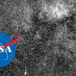
NASA satellite photo captures wildfire smoke in the US West Coast
Oct 6, 2020
Dunja Đuđić Kalinin
Dunja Djudjic is a multi-talented artist based in Novi Sad, Serbia. With 15 years of experience as a photographer, she specializes in capturing the beauty of nature, travel, concerts, and fine art. In addition to her photography, Dunja also expresses her creativity through writing, embroidery, and jewelry making.
Share:

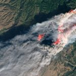
The wildfires in the US West Coast have been raging for a while now, destroying a record 4 million acres in California so far. NASA’s Aqua satellite captured the impressive, eye-opening, and above all devastating image of the fires that keep raging in the West.
Aqua captured the composite visible (left) and infrared (right) image on 29 September 2020. In the visible image, you can see the smoke, while the infrared image shows the heat from the fires and it’s marked with the orange points.
“NASA’s satellite instruments are often the first to detect wildfires burning in remote regions, and the locations of new fires are sent directly to land managers worldwide within hours of the satellite overpass,” NASA writes. “Together, NASA instruments detect actively burning fires, track the transport of smoke from fires, provide information for fire management, and map the extent of changes to ecosystems, based on the extent and severity of burn scars.”
According to some reports, one of the fires was caused by a smoke bomb.
[via PetaPixel; image credit: NASA]

Dunja Đuđić Kalinin
Dunja Djudjic is a multi-talented artist based in Novi Sad, Serbia. With 15 years of experience as a photographer, she specializes in capturing the beauty of nature, travel, concerts, and fine art. In addition to her photography, Dunja also expresses her creativity through writing, embroidery, and jewelry making.


Join the Discussion
DIYP Comment Policy
Be nice, be on-topic, no personal information or flames.