


ESA’s Earth from Space: Tulip Fields, Arctic Ice, and Volcanic Terrain
Jun 10, 2026
Soumyadeep Mukherjee
Soumyadeep Mukherjee is an award-winning astrophotographer from India. He has a doctorate degree in Linguistics. His work extends to the sub-genres of nightscape, deep sky, solar, lunar and optical phenomenon photography. He is also a photography educator and has conducted numerous workshops. His works have appeared in over 40 books & magazines including Astronomy, BBC Sky at Night, Sky & Telescope among others, and in various websites including National Geographic, NASA, Forbes. He was the first Indian to win “Astronomy Photographer of the Year” award in a major category.
Share:
Earth observation satellites now go far beyond producing weather maps and environmental datasets. Modern orbital imaging systems collect vast amounts of scientific information daily, utilizing multispectral sensors, synthetic aperture radar instruments, and high-resolution optical cameras. The European Space Agency continues to lead much of this work through the Copernicus programme and its Sentinel satellite fleet.
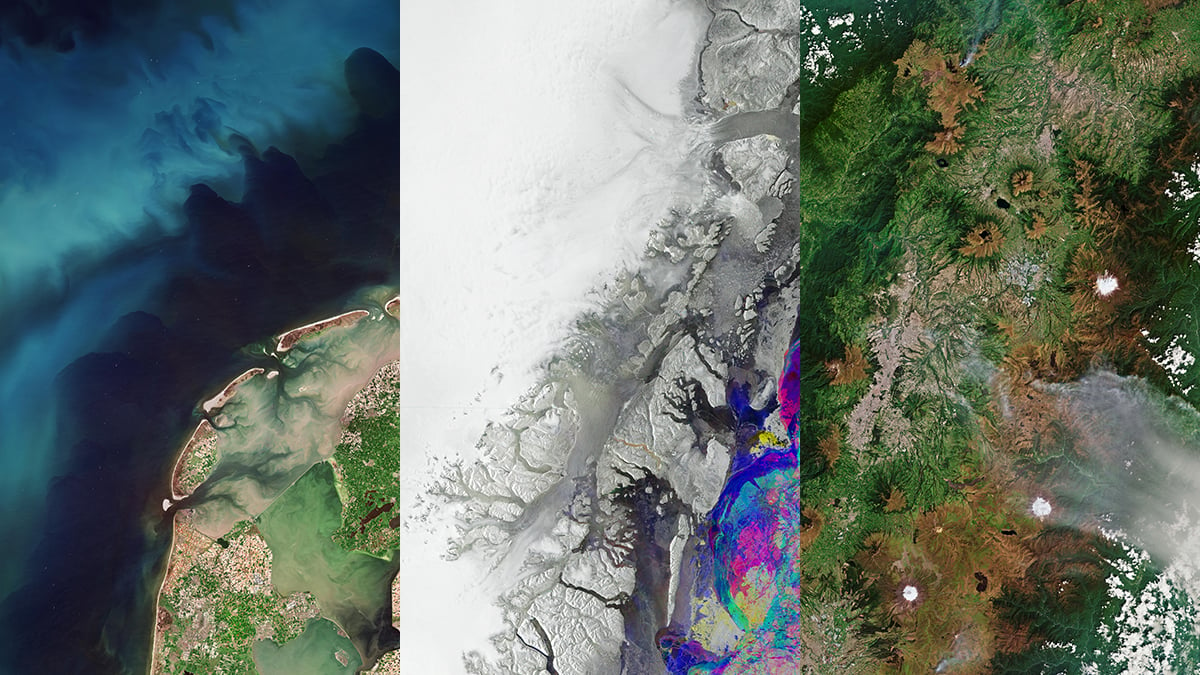
In May 2026, ESA released three remarkable images of the long-running “Earth from Space” series. One image captures the tulip-growing regions of the Netherlands during peak bloom. Another reveals Greenland’s evolving Arctic ice using radar-based composite imaging. And the third image focuses on Quito and the volcanic landscape surrounding Ecuador’s capital city.
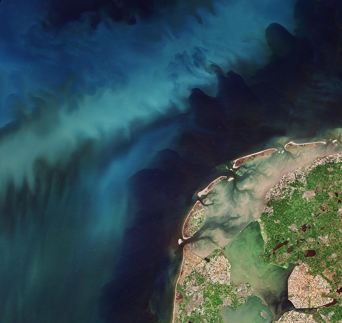
Netherlands in bloom: Agriculture and ocean biology
From orbit, the western Netherlands appears covered with geometric bands of colour stretching across the countryside. Tulip fields formed long rectangular sections in shades of red, yellow, orange, pink, and purple. Roads and canals separated the fields into neat agricultural blocks, giving the landscape a highly structured appearance. The image covered parts of North Holland and South Holland, regions known worldwide for commercial flower cultivation.
The scale of the cultivation became especially apparent from space. Ground-level photographs often isolate individual fields or flowers. The Sentinel-2 image, however, reveals the full extent of the agricultural network spread across the region. Thousands of hectares of farmland appeared carefully arranged across reclaimed coastal terrain.
Along the Dutch coastline, swirling green patterns appeared in the North Sea. ESA identified these formations as phytoplankton blooms developing in coastal waters during spring. Phytoplankton are microscopic marine organisms that contain chlorophyll and perform photosynthesis. Under suitable environmental conditions, their populations can expand rapidly and become visible from orbit.
Seasonal sunlight and nutrient-rich water helped trigger the bloom visible in the image. Rivers and coastal mixing processes supplied nutrients into shallow marine regions, allowing phytoplankton concentrations to increase. Sentinel-2’s multispectral instruments detected subtle colour differences associated with chlorophyll in seawater.
Greenland’s changing ice: Revealing Arctic instability
ESA’s “Greenland’s changing ice” originates from the Copernicus Sentinel-1 mission, which operates using synthetic aperture radar rather than optical imaging systems. ESA combined three separate radar acquisitions captured in January, February, and March 2026. The agency then assigned each acquisition to a different colour channel during processing. Areas that changed between observations produced strong colour contrasts, while stable surfaces remained darker or more uniform.
The composite focuses on northeastern Greenland, one of the most important glacial regions on Earth. Several major outlet glaciers appeared on the scene, including Nioghalvfjerdsfjorden Glacier, Zachariae Isstrøm, and Storstrømmen Glacier. These glaciers transport enormous volumes of ice from the Greenland Ice Sheet into the North Atlantic Ocean.
Sentinel-1’s radar system offers major advantages for observing polar environments. Optical satellites depend on sunlight and clear skies, both of which become unreliable in the Arctic. Greenland experiences long periods of winter darkness along with persistent cloud cover. Radar imaging avoids those limitations as the satellite actively transmits microwave signals toward Earth and measures the reflected return.
Greenland has experienced substantial ice loss over recent decades. Rising atmospheric and ocean temperatures continue to affect glacier stability across parts of the ice sheet. Some outlet glaciers have accelerated, retreated, or thinned considerably since the late twentieth century.

Quito’s volcanic landscape: Geography of a High-Altitude Capital
Quito occupies one of the most geographically unusual urban settings in the world. The city sits at an elevation of roughly 2,850 metres above sea level within a narrow Andean valley. Steep slopes and volcanic peaks rise around the urban region on nearly every side.
The image shows Quito stretching north to south through the valley floor. Mountain ridges restricted development toward the east and west, forcing the city into a long linear shape. That urban pattern became extremely obvious from orbit.
Several volcanoes dominate the surrounding landscape. Cotopaxi, Antisana, Cayambe, and Pichincha appeared prominently within the scene. Snow-covered peaks contrast sharply with darker volcanic terrain and densely populated urban districts below. Pichincha remains particularly important because it stands just beside Quito and continues to show volcanic activity. Quito is the only capital city located so close to an active volcano.
The image also captures smoke from wildfires linked to dry conditions during late 2025. Thin plumes drifted across sections of the region, adding another environmental layer to the observation. Satellites now play an important role in wildfire monitoring because they can detect active fires, smoke movement, burn scars, and vegetation stress across large areas.

Clear skies!

Soumyadeep Mukherjee
Soumyadeep Mukherjee is an award-winning astrophotographer from India. He has a doctorate degree in Linguistics. His work extends to the sub-genres of nightscape, deep sky, solar, lunar and optical phenomenon photography. He is also a photography educator and has conducted numerous workshops. His works have appeared in over 40 books & magazines including Astronomy, BBC Sky at Night, Sky & Telescope among others, and in various websites including National Geographic, NASA, Forbes. He was the first Indian to win “Astronomy Photographer of the Year” award in a major category.


Join the Discussion
DIYP Comment Policy
Be nice, be on-topic, no personal information or flames.