


This image of over one billion galaxies took six years to make
Feb 27, 2023
Dunja Đuđić
Dunja Djudjic is a multi-talented artist based in Novi Sad, Serbia. With 15 years of experience as a photographer, she specializes in capturing the beauty of nature, travel, concerts, and fine art. In addition to her photography, Dunja also expresses her creativity through writing, embroidery, and jewelry making.
Share:

Looking at a starry sky, or even just a photo of it, is one of my favorite feelings in the world. Scientists have just released a very special “starry sky” photo, the largest, most detailed of its kind.
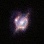
This is the largest 2D map of the sky ever made. It took six years and an enormous amount of data to complete it. And no wonder – it covers nearly half of the sky and shows more than one billion galaxies!
This remarkable map is the tenth data release from the DOE’s Dark Energy Spectroscopic Instrument (DESI) Legacy Imaging Survey. With this addition, , the Legacy Surveys have been expanded to over 20,000 square degrees.
The map shows 14,000 square degrees of the sky visible from the northern hemisphere. All the data were collected using a total of three telescopes at NSF’s NOIRLab’s Kitt Peak National Observatory (KPNO) and Cerro Tololo Inter-American Observatory (CTIO) in Chile. As I mentioned, it took six years to complete this ambitious task. It resulted in a whopping one petabyte of data and 100 million CPU hours to complete it! And it’s not just any computer, it’s one of the world’s most powerful computers at the US National Energy Research Scientific Computing Center.
Like all maps of this kind, it should help astronomers study and better understand the structure of dark matter, dark energy, and the universe in general. “Though all galaxies shine brightly, many are cloaked in dust while others are so distant that to observers on Earth they appear as little more than faint smudges,” Alfredo Zenteno of NSF’s NOIRLab writes in a statement. This is why it’s important to create comprehensive maps like this one.
“One of the main purposes of this map is to identify roughly 40 million target galaxies for the five-year DESI Spectroscopic Survey, which is aimed at understanding dark energy by precisely mapping the expansion history of the Universe over the last 12 billion years. The DESI project has selected its targets and the spectroscopic survey is currently underway. However, the team is looking to create the most comprehensive map of the sky that they can, so more images and improved processing have been added to the Legacy Surveys to include data that were previously missing.”
[via Digital Trends; image credits: DESI Legacy Imaging Survey/KPNO/NOIRLab/NSF/AURA; Image processing: T.A. Rector (University of Alaska Anchorage/NSF’s NOIRLab, Jen Miller, M. Zamani & D. de Martin (NSF’s NOIRLab)]

Dunja Đuđić
Dunja Djudjic is a multi-talented artist based in Novi Sad, Serbia. With 15 years of experience as a photographer, she specializes in capturing the beauty of nature, travel, concerts, and fine art. In addition to her photography, Dunja also expresses her creativity through writing, embroidery, and jewelry making.


Join the Discussion
DIYP Comment Policy
Be nice, be on-topic, no personal information or flames.