


New satellite takes photos of Earth’s temperature in incredible detail
Oct 16, 2023
Alex Baker
Alex Baker is a portrait and lifestyle driven photographer based in Valencia, Spain. She works on a range of projects from commercial to fine art and has had work featured in publications such as The Daily Mail, Conde Nast Traveller and El Mundo, and has exhibited work across Europe
Share:

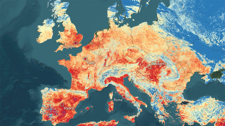
A new space-based satellite thermometer has taken to the skies, capturing Earth’s temperature in remarkable detail. HOTSAT-1, developed by London-based company SatVu, unveiled its first set of images showcasing temperature fluctuations across the planet’s surface.
These extraordinary images can accurately detect temperature differences, reaching as close as 33 feet (10 meters). The satellite’s onboard camera can even capture brief video clips. One even shows the heat signature of a moving train in Chicago.
Fire management
Another set of images reveals a thermal map of the wildfires that engulfed Canada’s Northwest Territories in June (see image below). This should help firefighters monitor advancing fire fronts, especially in areas close to populations.

High resolution
According to Tobias Reinicke, SatVu’s Chief Technical Officer and co-founder, the quality of the initial images from HOTSAT-1 has “exceeded” their expectations. “Thermal imaging has been done for decades by scientific missions like NASA’s Landsat and the European Sentinel satellites,” he says.
“But these satellites are only collecting thermal data at a very coarse resolution — 100 meters, 500 meters or 1,000 meters [330 feet, 1,650 feet or 3,300 feet]. There’s not been a commercial mission that is capturing data under 10 meters [33 feet] in the thermal spectrum,” he adds.
City planning
The groundbreaking high-resolution view of temperature variances on Earth’s surface offers potential benefits for city planners. It can help them understand how heat dissipates from structures like buildings, pipelines, and factories. This helps them to design more energy-efficient infrastructure to combat climate change.
Detecting heat (essentially infrared light) from space is challenging due to the longer wavelength of the signal. This needs a slower shutter, like a longer exposure on a camera. However, the satellite’s high speed at 7 kilometres per second (4.4 miles per second) demands precise positioning to avoid blurry images.
HOTSAT-1 started its orbit in June aboard a SpaceX Falcon 9 rocket from Vandenberg Space Force Base in California. This spacecraft measures roughly 3.3 by 3.3 by 3.3 feet (1 by 1 by 1 meter) and orbits the Earth’s poles, providing global coverage daily.
SatVu raised £30.5 million ($37.1 million) in venture capital funding and has plans to launch a second satellite within a year.
Cover image: SatVu’s HOTSAT-1 satellite
[Via Space]

Alex Baker
Alex Baker is a portrait and lifestyle driven photographer based in Valencia, Spain. She works on a range of projects from commercial to fine art and has had work featured in publications such as The Daily Mail, Conde Nast Traveller and El Mundo, and has exhibited work across Europe


Join the Discussion
DIYP Comment Policy
Be nice, be on-topic, no personal information or flames.
One response to “New satellite takes photos of Earth’s temperature in incredible detail”
No wonder that there’s a temperature rise around the earth. Especially when they usually measure the temperature in the middle of the cities.