


NASA releases incredibly high-resolution Earth-rise photo captured from above the lunar surface
Apr 26, 2016
Gannon Burgett
Gannon Burgett is a communications professional with over a decade of experience in content strategy, editing, marketing, multimedia content creation. He’s photographed and written content seen across hundreds of millions of pageviews. In addition to his communications work for various entities and publications, Gannon also runs his multimedia marketing agency, Ekleptik Media, where he brings his expertise as a full-stack creator to help develop and execute data-driven content strategies. His writing, photos, and videos have appeared in USA Today, Car and Driver, Road & Track, Autoweek, Popular Mechanics, TechCrunch, Gizmodo, Digital Trends, DPReview, PetaPixel, Imaging Resource, Lifewire, Yahoo News, Detroit Free Press, Lansing State Journal, and more.
Share:
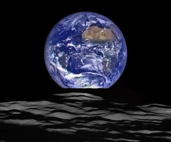
What you see above is not a 3D model made on a computer. It is a composition captured and created by the Lunar Reconnaissance Orbiter that depicts the earth rising over the surface of the moon.
Launched on June 18th, 2009, the Lunar Reconnaissance Orbiter (LRO) had a primary mission of mapping out the topography and polar regions of the moon. It did this through the use of multiple instruments, as well as an onboard camera, with a maximum resolution of 50cm/pixel (20in/pixel).

With its main mission completed within its year-long time-frame, a secondary mission as well as extensions have been placed on the LRO.
Reminiscent of the iconic ‘Blue Marble’ image, which was captured 43 years ago, this image features an almost identical composition in terms of what part of Earth is showing. In the words of NASA:
In this composite image we see Earth appear to rise over the lunar horizon from the viewpoint of the spacecraft, with the center of the Earth just off the coast of Liberia (at 4.04 degrees North, 12.44 degrees West). The large tan area in the upper right is the Sahara Desert, and just beyond is Saudi Arabia. The Atlantic and Pacific coasts of South America are visible to the left. On the moon, we get a glimpse of the crater Compton, which is located just beyond the eastern limb of the moon, on the lunar farside.
The LRO spacecraft was roughly 83 miles (134 kilometers above the moon’s surface at the time of capture, according to NASA.
It might not live up to the glory of the original Blue Marble, or the 2015 remake, but it’s an astounding image nonetheless. To see the full-resolution image, click here.

Gannon Burgett
Gannon Burgett is a communications professional with over a decade of experience in content strategy, editing, marketing, multimedia content creation. He’s photographed and written content seen across hundreds of millions of pageviews. In addition to his communications work for various entities and publications, Gannon also runs his multimedia marketing agency, Ekleptik Media, where he brings his expertise as a full-stack creator to help develop and execute data-driven content strategies. His writing, photos, and videos have appeared in USA Today, Car and Driver, Road & Track, Autoweek, Popular Mechanics, TechCrunch, Gizmodo, Digital Trends, DPReview, PetaPixel, Imaging Resource, Lifewire, Yahoo News, Detroit Free Press, Lansing State Journal, and more.
Related Posts
 NASA’s new satellite offers stunningly high resolution images of earth
 Student space programme sends Insta360 X3 more than 16 miles above Earth’s surface
 This 8K video lets you “fly” above an incredibly detailed Martian crater
 Does Adobe’s Super Resolution eliminate the need for high resolution cameras?
Join the Discussion
DIYP Comment Policy
Be nice, be on-topic, no personal information or flames.